Legacy talk:Cartography
Jump to navigation
Jump to search
Links
The Universe of Haven - by Xcom » Mon Feb 10, 2014
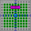
Constituent map-tile grid
Something that probably should go in a more general/technical gid-info page.
- A constituent map-tile, the 100x100 type, has its own general sub-grid. This sub-grid is used, for example, for displaying what a character can see (from the character current sub-grid position (9x9 sections).). Its also used by Beehive's as a additional range limiter. (Beehive also only acts on crops in a 3x3 section-area around the section that holds the beehive. Pollination order seems affected by these section to. )(Note: Beehive(13*2+1=27), Min Sub-grid section(3x9=27))
- Old sub-grid workout: (pixel type workout)

- --.MvGulik. 12:21, 6 February 2013 (EST)
General HnH world cord systems.
Something that probably should go in a more general/technical gid/cord/world-info page.
Running from big to small.
- The World: The whole darn thing. The total size of the world is determent by, and measured in, SuperGrid's. Generally used in uneven squared fashion, like 3x3, 5x5, 7x7, etc
- SuperGrid(SG): A fixed sized area with a size of 5000x5000 Map-tiles.
- Mini map: A specific area with a size of 125x125 Map-tiles. (The term "Mini Map" is generally also used for specifying Constitutional Map-tiles.)(see if there is something special about the 125x125 size, or else it could be ditched.)
- Constitutional (mini)Map: A specific area with a size of 100x100 Map-tiles.
- <name>: A Constitutional (mini)Map has its own sub-grid (see above section).
- Map Tile: The smallest ground/terrain unit there is. It has a size of 11x11 Map coordinates units.
- Map Cord: The base coordinate system that gives everything its place in the HnH World.
Other map types/names: (these only play a role inside the game as cartographic subjects.)
- Regional map = a specific area of 2500x2500 MapTiles. Each SG holds 4 regional map areas.
- Local map = a specific area of 500x500 Map-tiles. Each Regional map holds 25(5x5) Local maps. A Local map holds 25(5x5) Constitutional Map-tiles.
--.MvGulik. 14:55, 2 October 2013 (EDT)